

Maps
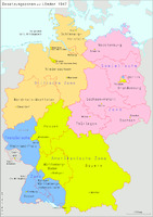
This map shows the American, British, French, and Soviet occupation zones in Germany in 1947. The Soviet Union's occupation zone, highlighted in pink, became East Germany (the GDR) in 1949.
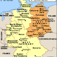
This map includes West Germany and East Germany. It shows the borders between the countries, their respective regional jurisdictions, and notable cities. This map accurately represents the GDR from 1952 until Germany's reunification in 1990.
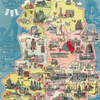
This map is a poster created to celebrate the GDR's 20th anniversary in 1969. It shows the GDR's national and regional borders and notable cities. In addition, the small drawings next to each city marker show what makes the city important and unique. The cities in the northern and western parts of the GDR are more likely to be represented by their Medieval, Renaissance and Baroque architecture. In contrast, depictions of factories and industries represent the cities in the eastern and southern parts of the GDR.